Chapter 01 : The internal structure of the Earth
| Introduction The Earth is the third planet in the solar system after Mercury and Venus. It is the only planet where life abundantly exists. In this chapter, you will learn about the Earth's internal structure, forces, and movements that operate within it. The competencies developed will enable you to develop disaster preparedness skills and address environmental impacts related to earthquakes, volcanic activities, and other Earth’s movements. |
Think
The internal structure of the Earth and its movements
| Activity 1.1 Use reliable online sources such as educational websites or geographical platforms to search for information about the internal structure of the Earth. Write a summary about the different internal layers of the Earth you observed. |
Concept of the internal structure of the Earth
The Earth’s structure is composed of two parts: internal and external. The internal structure, sometimes referred to as the inner zone, consists of three concentric layers: crust, mantle, and core (Figure 1.1). These layers are classified based on the density of their rock. The less dense rocks float on top of the denser rocks. The heavier elements, like iron and nickel, are most prevalent within the Earth’s core.
|
Figure 1.1: Cross-sectional view of the internal structure of the Earth |
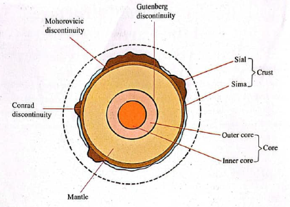
Crust
The crust is the outermost and thinnest of all Earth’s internal structure layers. It has a thickness of about 8 to 50 kilometres and an average density of 2.7g/$cm^3$. It consists of two sub-layers laying over one another, namely SIAL and SIMA. SIAL is the continental part of the crust, which is composed of different types of rocks. Rocks in the SIAL are rich mostly in silica and aluminium. The SIMA layer is beneath the SIAL. It is made up of basaltic rocks rich mostly in silica and magnesium. This layer makes up the ocean floor. SIMA and SIAL are separated by a layer known as the Conrad discontinuity. This layer was named after the seismologist Victor Conrad, who discovered it in 1925.
Mantle
The mantle lies between the core and the crust. It is made of very dense igneous rocks rich mostly in iron, silicon, oxygen, aluminium, and magnesium. It extends from 51 kilometres to about 2900 kilometres into the Earth. It consists of rocks with a density of about 3.0g/$cm^3$ to 3.4g/$cm^3$. Mantle is divided into two parts: the upper mantle and the lower mantle. The upper solid part of the mantle combines with the crust to form a larger lithospheric layer. A thin portion below the upper mantle is in a semi-molten material, creating an asthenosphere layer. The remaining part of the mantle is rigid; the convection currents generated in the lower mantle due to high temperaturetrigger various internal movements. A layer separating the mantle from the crust is called the Mohorovicic discontinuity, named after the seismologist Andrija Mohorovicic, who discovered it in 1909.
Core
The core also called the barysphere, is the innermost part of the Earth. It consists mostly of nickel and iron minerals, and is under tremendous pressure and heat, with an average density of about 10.5g/$cm^3$. The core is divided into outer and inner cores. The outer core is about 2300 kilometres thick. It comprises very hot molten rock materials composed mainly of iron and nickel. The movement of these molten materials generates powerful electric currents, which, in turn, create the Earth’s magnetic field. The magnetic field is essential for life on Earth as it protects the planet from harmful solar radiation and charged particles from the Sun. Without the outer core’s dynamic motion, Earth would likely lose its magnetic shield, making it difficult for living organisms to survive. The density and temperature constantly increase along the border between the mantle and core, and the outer core is liquid-like. The temperature in the rock along the border is about 3700°C. The inner core is solid due to the pressure exerted by other layers towards the centre. It has a temperature of about 5500°C and a density of about 16 - 17g/$cm^3$. The inner core has a diameter of about 2600 - 2700 km. The core is demarcated from the mantle by a layer called the Gutenberg discontinuity, named after the seismologist Beno Gutenberg, who discovered it in 1912.
| Activity 1.2 Use clay soil, modelling clay, dough, sponge material, tree leaves, or any available materials to create a model that shows the Earth’s internal structure. |
Exercise 1.1
- Describe the difference between the lithosphere and the asthenosphere.
- Explain why the inner core is solid even though it is the hottest part of the Earth.
- If the outer core were solid, how would that affect life on Earth?
- What would happen if the mantle suddenly stopped moving?
- Why do you think it is essential to understand the Earth’s internal layers?
The role of Earth's internal structure in rock formation
Each of these layers plays a critical role in the formation and distribution of rocks that define the Earth’s geological framework. The crust, being the outermost and thinnest layer, is particularly significant as it directly hosts the formation of a wide variety of rocks through geological processes such as the cooling of magma, sedimentation, and metamorphism. Igneous, sedimentary, andmetamorphic rocks are most commonly found and studied within this layer. However, the contribution of the crust cannot be fully understood in isolation. The mantle, lying beneath the crust, is the source of magma that forms igneous rocks, while intense pressure and heat from the mantle and the core influence metamorphic processes. Therefore, the formation of Earth's rocks is a dynamic interplay among all three layers, with the crust serving as the primary interface where these rocks emerge, are transformed, and contribute to the planet's continually evolving internal structure.
Rocks are natural solid materials composed of various minerals in different ratios. The rock cycle refers to the process by which a rock transforms from one type to another. Rocks differ in colour, texture, density, mode of formation, and resistance to erosion. They also vary in chemical composition, age, permeability, and hardness. The crust drives the rock cycle through volcanic activity, erosion, and plate movements, which form igneous, sedimentary, and metamorphic rocks.
Igneous rocks
The term 'igneous' comes from the Latin word ignis, which means fire. These are rocks formed by the process of cooling and solidification of molten materials (magma or lava). Crust influences the cooling rate and structure of igneous rock because it acts as an insulating layer. Igneous rocks are associated with volcanic activity, and their distribution is controlled by plate tectonics. The molten materials can be derived from partial melting of pre-existing rocks, which can be caused by one or more of the following processes: an increase in temperature, a decrease in pressure, and a change in composition. Magma cools and solidifies within the crust, while lava cools and solidifies on the Earth's crust.
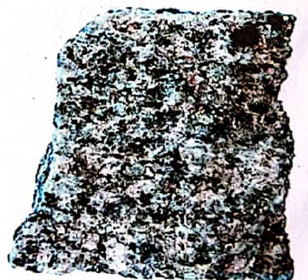
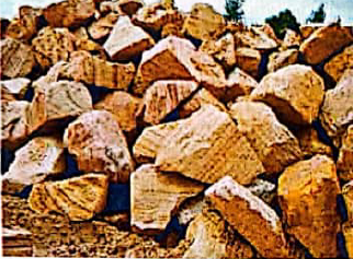
Intrusive igneous rocks: These are rocks formed when magma flows through vents or cracks, cools very slowly, and solidifies before reaching the Earth's surface. The slow cooling process of magma within the Earth's crust forms a large crystal. Such rocks include granite, gabbro, and diorite (Figure 1.2). The intrusive rocks also known as plutonic rocks are divided into two types: hypabyssal intrusive igneous rocks and plutonic igneous rocks.
|
Figure 1.2: Granite rock |
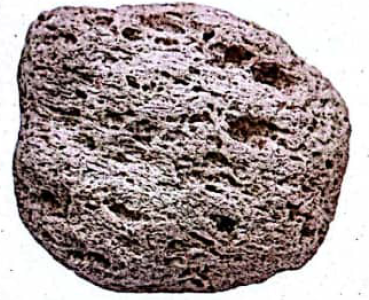
Extrusive igneous rocks: These are rocks formed on the Earth’s surface. They are also known as volcanic rocks. They are formed when magma erupts and reaches the Earth’s surface as lava, then cools and solidifies relatively quickly. Examples of these rocks are basalt, pumice, and rhyolite. In Tanzania, basalt, pumice, and rhyolite are found in regions such as Kilimanjaro, Mbeya, and Arusha (Figure 1.3).
|
Figure 1.3: Pumice rock |
Characteristics of igneous rocks
These rocks are hard and crystalline, as they do not occur in layers. They do not contain fossils, can undergo metamorphism to form metamorphic rock, or can be weathered to form sedimentary rocks, and they mostly contain iron and magnesium minerals.
Sedimentary rocks
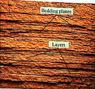
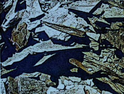
Sedimentary rocks are found in strata. These rocks are formed by depositing eroded materials transported by moving water, wind, ice, ocean currents, waves, and drift. They result from continued weathering and erosion, transportation, deposition, and lithification (compaction and cementation) of sediments. Most of sedimentary rocks are in horizontal layers called strata (Figure 1.4). The strata are separated from each other by a surface known as a bedding plane. They exist in various views. Sedimentary rocks are not crystalline. They often contain fossils of dead living things collected by winds, water, ice, ocean currents, and drift. There are three types of sedimentary rocks according to their mode of formation. These are mechanically formed sedimentary rocks, organically formed sedimentary rocks, and chemically formed sedimentary rocks.
|
Figure 1.4: Sedimentary rock |
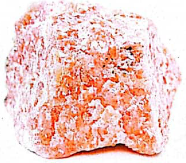
Mechanically formed sedimentary rocks: These rocks are formed by the deposition of sediments from eroded materials of existing rocks. Examples of mechanically formed sedimentary rocks are sandstone, mudstone, shale, and boulder clay. Alluviums are deposited by water, moraines by ice, and loess by wind. These types of rocks have different economic uses. For example, sandstones make building blocks (Figure 1.5).
|
Figure 1.5: Sandstone |
Organically formed sedimentary rocks: These are rocks formed from the deposition of plant and animal remains. Examples of such rocks are limestone, chalk, and coral from animals, peat, coal, and lignite from plants (Figure 1.6). These rocks have various uses. For example, chalk is used in cement and paint factories, while coal is an energy source for industrial and domestic uses.
|
Figure 1.6: Limestone |
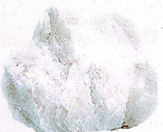
Chemically formed sedimentary rocks: These rocks are created by depositing solid substances from solutions; examples include rock salt, gypsum dolomite, potash, and nitrate gypsum (Figure 1.7). These rocks also serve as key ingredients in the manufacturing of inorganic fertilizers and in the building materials industry.
|
Figure 1.7: Gypsum dolomite |
Characteristics of sedimentary rocks
Sedimentary rocks are soft and well-jointed, stratified, contain fossils, can undergo metamorphism to form metamorphic rocks, and are non-crystalline.
Metamorphic rocks
The word metamorphic is derived from two Greek words, ‘meta’ and ‘morph’. Meta means change, and morph means form. So, metamorphic means to change form. Metamorphic rocks are formed when igneous and sedimentary rocks are subjected to great heat and pressure. They change their physical and chemical properties and form new types of rocks called metamorphic rocks. There are three main types of metamorphic rocks based on their mode of formation.
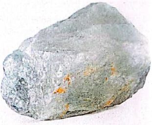
Thermal metamorphic rocks: This type of rock is formed when the existing rocks comes into contact with magma or lava, resulting in a change of form and character. These rocks are formed by intense heat. Examples are limestone to marble and sandstone to quartzite (Figure 1.8).
|
Figure 1.8: Marble |
Dynamic metamorphic rocks: These are formed by the influence of pressure exerted by the Earth’s horizontal and vertical movements, which also cause mountain formation. Examples are shale to schist and clay to slate (Figure 1.9).
|
Figure 1.9: Slate |
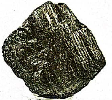
Thermal-dynamic metamorphic rocks: These rocks are formed by intensive temperature and pressure. An example is when coal changes to graphite (Figure 1.10).
|
Figure 1.10: Graphite |
Characteristics of metamorphic rocks
Metamorphic rocks are harder than all other types of rocks. They are sometimes found in strata but in a crystalline form. They are formed from other types of rocks due to the influence of intense heat and pressure, and can change into other types of rocks.
The internal forces of the Earth
Internal forces, also known as endogenic forces, originate and operate within the Earth’s crust. These forces result from energy produced by internal heat, chemical reactions within the Earth, and the transfer of rock materials to the Earth’s surface. Internal forces that shape the Earth’s surface begin underneath the lithosphere and cause vertical and horizontal movements of the Earth.
The internal Earth’s movements
These are movements of the solid parts of the Earth. Rocks may move towards each other, away from one another, one part another, or upward and downward within the Earth’s crust. The forces working from inside the Earth are responsible for these movements. The Earth’s movements normally result in the formation of new structural features. The forces that cause Earth’s movements and their associated structural features are known as diastrophic forces.
Since these movements occur on the actual structure of the Earth’s crust, they are also called tectonic movements. The word tectonic is derived from a Greek word tekton, which means builders. The Earth’s movements bring enormous changes to the Earth’s surface. They are responsible for occurrence of fractures, bends, subsidence, or down-warping, and up-warping of the Earth’s crust that create different features, such as joints, depressions, and mountains.
Type of Earth’s movements
There are two types of Earth’s movements: vertical or radial and horizontal or lateral. The two movements exert great tensional and compressional forces, which become a basis for analyzing the resulting landforms. These movements cause the crustal rocks to either fold, fault, or form joints.
Horizontal movements, also referred to as lateral movements, typically involve sideways displacement of the lithosphere induced by compressional and tensional forces. These lateral movements play a key role in mountain formation (orogeny). It is through this process that many of the world’s fold mountains, including the Himalayas, Rockies, Andes, Alps, and Atlas Mountains were created. Additionally, horizontal movements contribute to the formation of faults, block mountains, and rift valleys, among others.
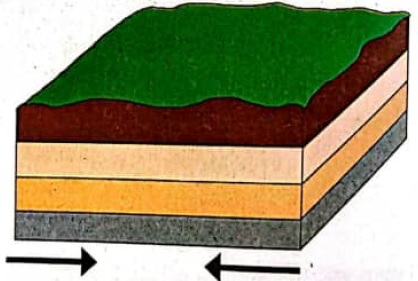
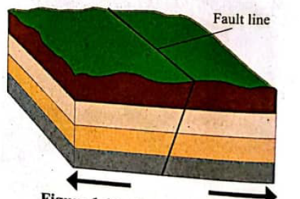
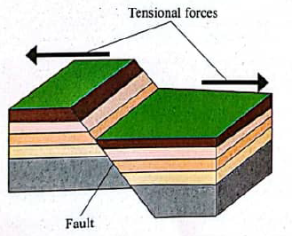
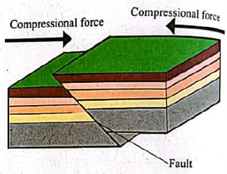
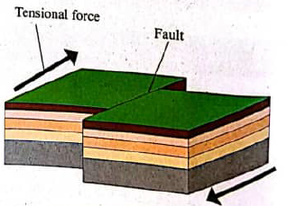
These movements are a result of compressional or tensional forces. Compressional forces are those that cause crustal rocks to move towards each other. On the other hand, tensional forces pull crustal rocks in opposite directions, causing rocks to move apart. While compressional forces produce reverse faults and folding, tensional forces produce normal faults (Figures 1.11 and 1.12).
|
Figure 1.11: Compressional forces |
|
Figure 1.12: Tensional forces |
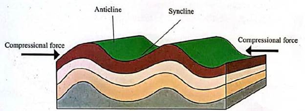
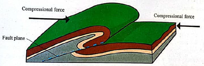
Folding
This refers to the bending of the Earth’s crust caused by compressional forces. The folds are formed when the crustal rock is subjected to weak and intense compressional forces. As a result, upfolds (anticlines) and downfolds (synclines) emerge, as shown in Figure 1.13. The sides of the fold are called limbs. The nature of the fold depends on the intensity of the forces involved.
The continuous process of folding results in a series of complex and extensive anticlines and synclines on the Earth’s crustal rocks, thus forming a range of mountains called Fold Mountains, as shown in Figure 1.13. Most of the highest mountain ranges in the world fall under the category of fold mountains. Examples of fold mountains include the Andes in Latin America, the Rockies in North America, the Himalayas in Asia, and the Alps in Europe. The Atlas and the Drakensberg mountains are vivid examples of fold mountains in Africa.
|
Figure 1.13: Anticline and Syncline |
Types of folds
Folding, which results from a compressional process, may cause the formation of different types of folds, namely, simple folds, asymmetrical folds, overfolds, and over-thrust folds.
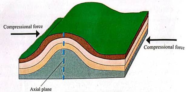
Simple fold
This is a type of fold in which the limbs incline at the same angle, as shown in Figure 1.14. It occurs when forces on both sides are of equal strength. When the angles of the anticline and syncline are almost equal, the fold is called a simple fold. It is also known as a symmetrical fold. This means the slopes on both sides of the fold (anticline or syncline) are almost uniform.
|
Figure 1.14: Simple fold |
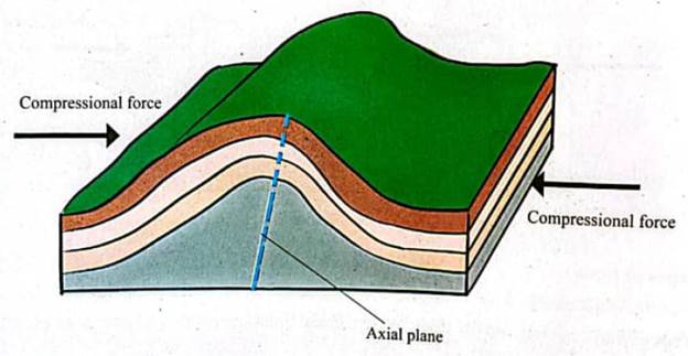
Asymmetrical fold
This is a type of fold in which one side of the limb is steeper than the other. It occurs when one side of the simple fold is subjected to a greater force than the other sides, and the side subjected to greater force becomes steeper than the other (Figure 1.15).
|
Figure 1.15: Asymmetrical fold |
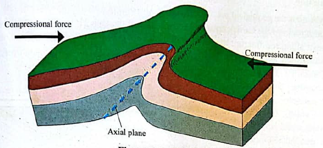
Overfold
This type of fold is also called a recumbent fold. It is a type of folding in which one anticline limb of asymmetrical fold is pushed over the other. The intensive folding movement is caused by compressional forces on one side, as shown in Figure 1.16. Overfold or recumbent folding happens when a high compressional force is exerted on an asymmetrical fold.
|
Figure 1.16: Overfold |
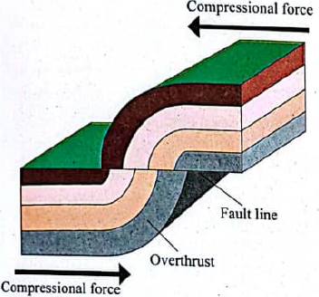
Overthrust fold
This is a fold formed when one limb of overfold is pushed further over another limb due to compressional forces (Figure 1.17). It occurs when there is great pressure on an overfold, enough for the rocks to fracture and a mass to thrust forward several kilometres along the fault plane or fracture.
|
Figure 1.17: Overthrust fold |
| Activity 1.3 Take a towel and soak it in water until it is completely wet. Lay the wet towel flat on a table (horizontally), then place both hands at opposite ends of the towel. Gently push the ends of the towel toward each other to compress it. Observe the changes in the towel’s appearance and describe how its folds resemble landforms created by natural folding processes. |
Faulting
Faulting is the geological process through which rocks of the Earth’s crust crack and move along the fracture due to tectonic forces such as tension or compression or shearing. Faulting is normally caused by either compressional or tensional forces accompanied by lateral or vertical movements. Tensional forces cause normal faults while compressional forces cause reverse faults. Features produced through faulting include rift valleys and block mountains (horsts).
Types of faults
A fault is a fracture or rupture in the crustal rock that causes displacement of its sides relative to each other. There are five types of faults: normal, reverse, tear, overthrust, and monocline.
Normal fault
A normal fault occurs when the inclination of the fault plane and the direction of the down-throw are either to the left or to the right. This type of fault results from tensional forces, as shown in Figure 1.18.
|
Figure 1.18: Normal fault |
Reverse fault
This occurs when the beds of rocks on one side of the fault plane in the normal fault are thrust over the other. It is a type of fault that results from compressional forces, as shown in Figure 1.19.
|
Figure 1.19: Reverse fault |
Transform fault
A transform fault is also called a strike or tear fault. It usually leads to the occurrence of earthquakes. It is a vertical fracture produced when two rock blocks slide against one another, resulting in horizontal displacement along the line of the fault, as shown in Figure 1.20.
|
Figure 1.20: Transform (Tear) faults |
Overthrust fault
This is a fault within the overthrust fold along which one limb slides over the other limb due to intensive compressional forces, as shown in Figure 1.21.
|
Figure 1.21: Overthrust faults |
Vertical movements also known as radial movements. These are movements occurring either upward or downward within the Earth's crust. Vertical movements are also referred to as epeirogenic movements because they are usually on a large scale. Vertical movements cause uplift or subsidence of wide-ranging areas of the crust. They are responsible for the formation of extensive landscape features like plateaus, basins, block mountains (horsts), rift valleys, and some types of escarpments called fault line scarps. Vertical movements may also result in emerged or submerged coasts.
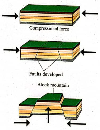
Block Mountain
A block mountain refers to a table-like mountain formed as a result of vertical movements of the blocks in the Earth's crust that lead to the rising of a fault-bounded block. Uplifted blocks may either be tilted, when they form tilt blocks, or horizontal, when they form horsts. A block mountain can be formed by either tensional or compressional forces. This is when the Earth's movements cause parallel faults, which result in the uplifting of some parts, as shown in Figure 1.22. Examples of block mountains are Usambara, Pare, and Uluguru in Tanzania, Ruwenzori in Uganda, Sinai in Asia, and the Vosges and Black Forest in Europe.
|
Figure 1.22: Formation of a block mountain |
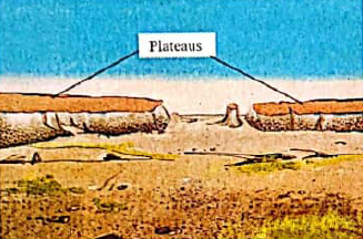
Plateau
A plateau is a large, extensive, and uplifted part of the Earth's crust, almost flat at the top (Figure 1.23). The formation of plateaus dates back to the Mesozoic and Jurassic eras. Such landforms include those of East Africa and the Brazilian plateaus. HighPlateaus, especially in tropical latitudes, are utilized in various ways, including agriculture and settlements.
|
Figure 1.23: Plateaus |
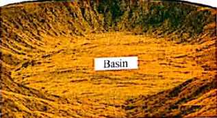
Basin
A basin is a large, extensive depression formed by the sinking or down-warping of the Earth’s surface, as shown in Figure 1.24. Examples of basins formed in this way are the Lake Victoria basin in Tanzania, the Lake Chad basin in central Africa, and the Amazon basin in South America. Some basins are formed by river deposition. A good example of such basins includes the Congo Basin in the Democratic Republic of Congo.
|
Figure 1.24: Basin |
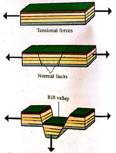
Rift valley
A rift valley is a narrow trough between parallel faults, with throws in opposite directions forming a long steep-sided valley. Such a valley is long proportional to its width. It is formed from vertical and lateral movements of the Earth’s crust when two faults develop in parallel. It can develop either by tensional or compressional forces.
Formation of a rift valley by tensional forces
A rift valley is formed when tensional forces pull the two sides of parallel faults apart, leaving the centre to subside. Extreme tensional forces break up rocks along the stratum, leading to cracks and fractures in the Earth’s crust. A block between the two parallel faults subsides to form a valley (Figure 1.25). Examples of rift valleys formed by tensional forces are the East African Rift Valley, the Jordan Rift Valley in Asia, and the Rhine Rift Valley in Europe.
|
Figure 1.25: Formation of a rift valley by tensional forces |
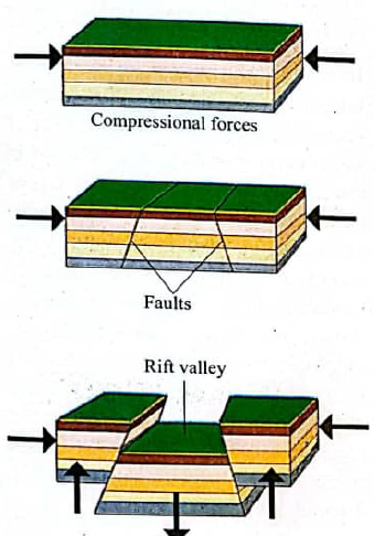
Formation of a rift valley by compressional forces
The valley is formed in such a way that the masses on either side of the faults thrust up higher than the central block, which is forced down between the two to form the valley. Otherwise, these forces of compression, because of two reversed faults, and the pieces of land on either side lift up above the general level of the ground to form a rift valley, as shown in Figure 1.26.
|
Figure 1.26: Formation of a rift valley by compressional forces |
When filled with water, a rift valley may form a lake. Examples of rift valley lakes in Africa include Tanganyika, Nyasa, Rukwa, Magadi, Baringo, Naivasha, Eyasi, Natron, Turkana, Edward, and Albert.
| Activity 1.4 Use the available materials to create physical models using clay or foam to represent different types of faults. Manipulate the models to simulate how the Earth’s crust moves during each type of faulting and observe how the landforms change. Present your work to the class, explaining the processes involved and the real-life implications of each fault type. |
Exercise 1.2
- Compare and contrast the effects of faulting and folding on the landscape.
- Explain how internal forces shape the Earth’s surface.
- Explain ways human activities can worsen the Earth’s surface.
- What would your advice be to a community that depends on limestone (sedimentary rock) for making cement, but the mining process affects the environment?
- Describe economic activities that people engage in relative to the type of rock found in the area. Provide vivid examples in your answers.
Volcanicity
Vulcanicity refers to the processes through which molten materials and gases are forced from the Earth’s interior into and onto the Earth’s surface to form either intrusive rocks within the Earth’s crust or extrusive rocks on the Earth’s surface. Vulcanicity is a wider term that comprises both intrusive and extrusive igneous activity, whileVolcanicity refers to the process through which molten rock (magma) moves from the Earth’s interior and erupts onto the Earth’s surface. When molten materials are still inside the crust, they are referred to as magma, but on reaching the surface, they lose gases, and thus, they are referred to as lava. Features formed by extrusive volcanicity, therefore, are known as volcanoes.
Rocks formed within the Earth’s crust are under high temperatures and great pressure; hence, they are in the molten state. When a crack or fault (fissure) or a hole (vent) is formed, magma is forced out through them quietly or violently. The nature of intrusive or extrusive volcanic features formed depends on the degree of fluidity or viscosity of the magma. More viscous magma has a high resistance to flow due to the high silica content than iron content. Less viscous magma flows rapidly and spreads further and forms a gentle dome shape due to high amount of iron content and less silica content. When magma flows slowly and solidifies near the vent and forms a steep dome shape. Most intrusive volcanic features result mainly from more viscous magma. The nature of the rock, weakness, such as joints, faults, cracks, or fissures, also determines the speed and position of the resulting volcanic features.
Causes of volcanicity
Volcanicity may occur due to the exertion of the excessive weight of overlying rocks on the mantle. The exerted force of rocks over the mantle increases the pressure and temperature of rocks and keeps them in a molten state. Volcanicity can also result from the friction along rock surfaces at the boundaries of tectonic plates. The friction raises the temperature and pressure where cracks are erupted or magma through the cracks. Furthermore, surface water infiltrates the ground where it comes across steeply heated rocks, and due to an increase in water, then, its temperature and pressure increase, thus, it shoots or flows out of the Earth’s crust as hot springs or geysers. Both intrusive and extrusive volcanicity result in a creation of various land forms.
Intrusive features
Intrusive features are formed when magma fails to reach the Earth’s surface and therefore cools and solidifies within the Earth’s crust. In this case, the magma may spread, accumulate, or remain in the passage within the crustal rocks where it cools and solidifies to form intrusive igneous features. The intrusive igneous features are categorised into abyssal and plutonic features. Hypabyssal features are formed beneath the Earth but nearer the surface, while plutonic features are formed deeper beneath the Earth. Intrusive features include dykes, sills, laccoliths, lapoliths, phacoliths, and batholiths.
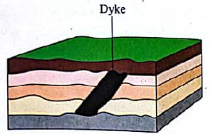
Dyke: It is a wall-like feature formed when a mass of magma cools and solidifies across the bedding planes of the rocks. (Figure 1.27). Since it does not follow the nature of the bedding plane of the rocks, it is a discordant feature. Examples of dykes are found in Jos Plateau in Nigeria, and West and South of Blantyre along the Tyolo Scarp in Malawi.
|
Figure 1.27: Dyke |
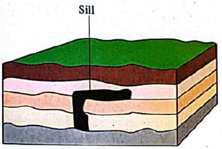
Sill: This is a sheet of igneous rock that forms when magma cools and solidifies horizontally along the bedding plane, as shown in Figure 1.28. It takes thicknesses of different sizes and can cover many kilometres. When exposed to erosion, the sill may form a ridge-like escarpment or a waterfall. The natural bridge in Kiwira, Mbeya in Southern Tanzania is an example of a sill. Other examples are found in South Africa along the railway line from Kimberly to Cape Town, and the sill formed the Kinkon Falls in Guinea.
|
Figure 1.28: Sill |
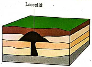
Laccolith: This is a dome-shaped intrusive feature formed within or between layers of sedimentary rocks, as shown in Figure 1.29. It is formed when the pressure of the viscous magma becomes high enough to force the overlying strata to fold and push up, creating a dome or mushroom-like structure
|
Figure 1.29: Laccolith |
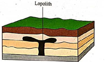
Lopolith: A lopolith is a large saucer-like intrusive igneous rock lying concordant to the rock strata, forming a shallow basin, as shown in Figure 1.30. It is formed by the greater weight of the overlying strata and deposits. An example of a lopolith is in the Bushveld Basin in the Transvaal, South Africa.
|
Figure 1.30: Lopolith |
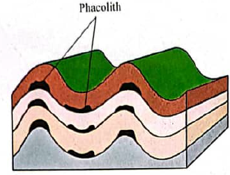
Phacolith: A phacolith is a lens-shaped igneous intrusive rock that is found in folded sedimentary layers. This is the concordant intrusion of igneous rock, formed after cooling and solidification of magma near the crest of anticline or the base of a syncline (Figure 1.31). A phacolith can form along the concordant sedimentary bedrock, exerting great thickness along the synclines or anticlines.
|
Figure 1.31: Phacolith |
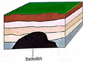
Batholith: This is a large body of igneous rock formed at the base of the Earth’s crust. It is formed by the intrusion and solidification of magma very deep in the crust, as shown in Figure 1.32. It is commonly composed of coarse-grained rocks. Most batholiths intrude across mountain folds and are elongated along the dominant axis of the range. A batholith forms the root-base of a mountain.
|
Figure 1.32: Batholith |
Extrusive features
These features are formed when molten materials reach the Earth’s surface through vents or fissures. The molten materials that are ejected onto the surface are called lava.
A silent eruption is an ejection of magma that takes place without involving much force. Some extrusive features take place through fissures; therefore, they are called fissure eruptions. Violent eruptions usually occur through a vent and take place with great force.
Volcanoes
A volcano is formed from the accumulation of molten rock that flows through a vent onto the Earth’s crust. The mountain’s funnel-like depression or vent around which the erupted materials accumulate is called a crater. Volcanoes are categorized as active, dormant, or extinct.
Active volcano: An active volcano is one that regularly erupts. Examples include Mount OldoinyoLengai in Tanzania, Mount Longonot in Kenya, Mount Nyiragongo in Democratic Republic of Congo, and Mount Pinatubo in Philippines.
Dormant volcano: A dormant volcano erupts rarely but still shows the signs of eruption. Such signs include rumbling, gaseous emissions, and lava flow, which indicate the likelihood of a volcano erupting again. Mount Kilimanjaro, Mount Meru in Tanzania, and Mount Menengai in Kenya are good examples of dormant volcanoes.
Extinct volcano: An extinct volcano is one that has stopped erupting permanently and shows no signs of erupting again. This type of volcano is no longer characterized by signs such as rumbling, smoke emission,lava flow, or ash. Denudation may have destroyed much of its original structure. Examples of extinct volcanoes include Mpolu in Tanzania, Kulod in Kenya, as well as Mikeno, Karisimbi, and Sabinyo in Uganda. Volcanic activities may form several features described in the following sub-sections. These include ash and cinder cones, composite cones, volcanic plugs, craters, and calderas.
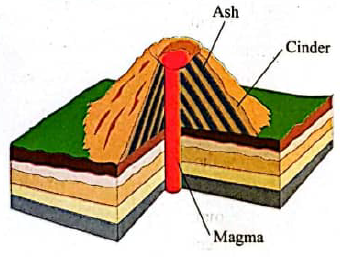
Ash and cinder cones
These are cone-shaped accumulations of rock fragments (pyroclasts) around the vent. They are formed when lava is blown and ejected violently to great heights, falling back to the Earth and building up a cone-like feature (Figure 1.33). The slopes of the cone are always concave due to the tendency of lava spreading at the base of the cone. Examples of ash and cinder cones are BarabaleFileko in Rungwe (Southern Tanzania), Busoka and Bitale (South West Uganda), South of Lake Turkana (Northern Kenya), and the Jos Plateau (near the centre of Nigeria).
|
Figure 1.33: Ash and cinder cone |
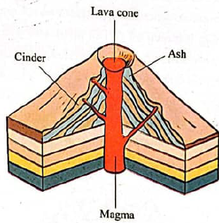
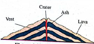
Composite cone (strato-volcano)
It is a large cone with alternative layers of lava and ash. Lava then erupts from the sides of the cone, where it builds up small conelets, as shown in Figure 1.34. The cone has steep-sided slopes, and it is the most common volcano. Examples of composite cones are the Kilimanjaro and Meru mountains in Tanzania, Nyiragongo Mountain in the Democratic Republic of the Congo, and Muhavura Composite in the East of the Virunga Ranges in southwest Uganda.
|
Figure 1.34: Composite cone |
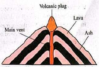
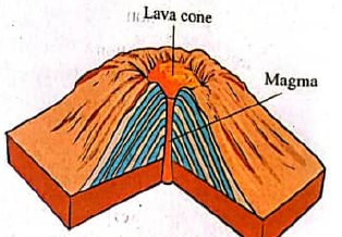
Volcanic plug
A volcanic plug is also known as a plug dome or spine volcano. It is formed when a mass of very viscous and magma is forced out through a vent from the ground (Figure 1.35). The plug is extruded and clouds of hot, blowing ash and cinders. An example of a plug dome is Mount Hoggar in Algeria.
|
Figure 1.35: Volcanic plug |
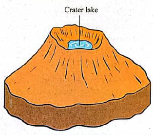
Crater
A crater is a depression on top of a volcanic cone. It is formed by violent volcanic eruptions when the upper part of a volcanic plug is blown off. When filled with water from either rainfall or melting ice, the depression may turn into a crater lake, as shown in Figure 1.36. Examples of craters are Ngorongoro, Embakasi, Olmoti, and Ngozi in Tanzania.
|
Figure 1.36: Crater |
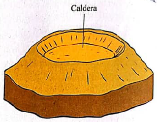
Caldera
It is a large, rounded depression formed when the upper part of a volcano is either blown away by violent eruptions or subsides into the crust of the volcanic cone, as shown in Figure 1.37. A caldera is a broader crater. Examples are Eboga Caldera in Cameroon and Katmai Caldera in Alaska.
|
Figure 1.37: Caldera |
Acid lava cone (Cumulo dome volcano)
It is a dome-shaped volcano with (convex) steeply sloping sides formed when acidic lava cools and solidifies around the vent, as shown in Figure 1.38. Due to its viscosity, lava does not flow away; rather, it piles up near the vent. The viscosity of the lava that forms a cupola dome results from its high silica content and melting point. An example of a cumulo dome is the Ntumbi dome in Madundumi in Chunya District, just 30 km East of Mbeya Region in Tanzania.
|
Figure 1.38: Acid lava cone |
Shield volcano
A shield volcano is an extensive cone with gentle slope sides formed when basic (basalt) lava is poured onto the surface and spreads to occupy a large area, as shown in Figure 1.39. Lava from the Earth’s interior flows out through a vent. A basic or shield volcano can also form when lava flows through a single or multiple fissures. An example of shield volcano is the Kitumbeine located in Longido District of Arusha Region in Tanzania.
|
Figure 1.39: Shield volcano |
The economic Importance of volcanic activities
Volcanoes have enormous economic importance. For instance, volcanic materials:
(a) Produce fertile soil that supports agricultural activities, both cash and food crop production.
(b) Result in the formation of precious stones and minerals, like gold from Geita in Tanzania and silver from Kakamega, Kenya. Minerals bring foreign currency, which is used to develop the country’s economy.
(c) Facilitate geothermal energy production because when magma rises near the Earth’s surface, groundwater is superheated. Hot water is pumped out as steam when a well is drilled. In these regions due to the extreme heat. The steam can then be used to drive turbines and produce domestic, industrial, and office electricity. An example is Iceland, where over 90% of homes are heated through geothermal energy. It may also be used to generate thermoelectric power and geysers and hot springs.
(d) Volcanic eruptions are also accompanied with releases of gases, ashes, and water vapour. Some of the gases released during volcanic activity include carbon dioxide (CO₂), sulphur dioxide (SO₂), and hydrogen sulphide (H₂S). These gases have potential economic importance: Tanzania extracts carbonic dioxide gases in Kyejo of Busokelo District and other parts of Rungwe in Mbeya Region.
(e) Provide building materials; for instance, igneous rocks are used for building and constructing roads. Basalt, diabase, and pumice are good examples.
(f) Features that result from volcanic activities attract tourists. For example, snow-capped volcanoes, such as Mount Kilimanjaro, Mount OldonyoLengai, and craters, such as the Ngorongoro crater in Arusha, attract tourists. Some tourists like hiking, nature and sightseeing as well as exploring wildlife and their natural habitat. Tourists bring in foreign currency and create employment opportunities among the citizens.
(g) Influence the formation of orographic rainfall after volcanic mountains are formed. For example, the windward side of Mount Kilimanjaro receives adequate rainfall that supports agricultural activities. Additionally, some volcanic features are sources of rivers that can be harnessed in dams and be used to produce electricity or for irrigation and fish-farming activities. For example, the source of the Pangani River, whose water is used to generate hydroelectric power at Hale and NyumbayaMungu Electrical Power Stations, is Mount Kilimanjaro.
Negative effects of volcanic eruptions
Lava and mudflows caused by volcanic eruptions may kill people and destroy properties as they erupt and flow rapidly down the volcano's sides. The lava flow can also destroy agricultural land since the solidified lava hardens, making it difficult for farmers to cultivate the land. Moreover, volcanic eruptions may release poisonous gases such as sulphur dioxide and carbon dioxide, adversely impacting human beings and the atmosphere.
| Activity 1.5 Use available materials to design a model demonstrating how magma moves beneath the Earth's crust and leads to volcanic eruptions. |
Exercise 1.3
- Explain the concept of vulcanicity and state how it occurs.
- Compare and contrast between intrusive and extrusive volcanic eruptions.
- Explain the negative effects of a volcanic eruption on the surrounding community.
- Explain how volcanic soils can influence agricultural activities.
- Elaborate on why some people live near volcanoes despite the risks.
- Describe measures to be taken before, during, and post volcanic incident.
Earthquakes
An earthquake is a sudden vibration, shaking or tremor of part of the Earth's crust caused by natural forces operating beneath the Earth's crust. Earthquakes usually occur in faulted and volcanic areas. Sometimes, earthquakes occur in zones where tectonic plates converge or diverge from one another or slide over or past one another. The intensity of an earthquake can be detected and measured using an instrument called a seismograph. The instrument is also known as a seismometre. The point in the Earth's crust where an earthquake originates is known as the focus. When the earthquake begins, its vibrations first hit the area called the epicentre before spreading out. The epicentre is the point on the Earth's surface that is vertically and immediately above the point of origin (focus) of an earthquake.
Causes of the earthquake
One of the causes of earthquakes is the isostatic adjustment of the Earth’s crust. This happens as the crust adjusts itself to changing pressure caused by the weight exerted on the Earth’s crust. The crust may move downwards or upwards. These movements then trigger strong seismic waves in the upper mantle, which lead to earthquakes. These movements may also make the Earth adjust along faults. Another cause of earthquakes is tectonic movements along fault lines in the crust, where one plate slides over the other. Such movements cause disturbances, generating shock waves that shake the Earth’s crust.
Vulcanicity can also cause earthquakes. This is because magma moving under the influence of internal pressure of the Earth’s interior erupts, leading to shaking of the Earth’s surface. Moreover, mass movements like landslides and rockfalls can also cause minor tremors. Falling heavy objects from the atmosphere, such as meteorites, can lead to the shaking of the Earth’s crust. Furthermore, tremors can be influenced by human activities like military use of bombs, as well as the use of explosives, dynamite in quarrying and mining.
Effects of earthquakes
Earthquakes are associated with faulting, folding, or even vulcanicity. When an earthquake occurs, it causes shaking of the ground, which may rupture part of the Earth’s crust due to tensional and compressional forces. This may result in vigorous movement of magma and gases in the Earth’s interior and may trigger an extrusive volcanic action. Moreover, when earthquakes occur in the ocean, they may cause ocean waves called Tsunamis. These waves are very high, and when they reach the coast, they cause flooding. The Indian Ocean Tsunami of 26th December 2004 caused over 200,000 deaths of people in Indonesia, also causing immense damage across 14 other countries along the Indian Ocean, including Tanzania. Similarly, lateral and vertical displacement of parts of land can occur. For instance, in San Francisco in 1906, an earthquake caused the horizontal displacement of rocks by 7 metres.
Earthquakes can also damage transport and communication lines, such as roads and oil pipelines, telephone lines, and roads. They can also raise or lower coastal rocks. For example, the 1809 Alaskan earthquake raised some coastal areas by 16 metres. Destruction of houses and other structures and the loss of human life significantly impact livelihood. For example, in 1906, an earthquake killed 700 people and caused substantial property loss in San Francisco. In Tanzania, the earthquake that occurred in Bukoba District, in the Kagera Region on 10th September 2016, caused deaths of more than 20 people, and about 1264 buildings were destroyed. Earthquakes can also cause part of the sea floor to rise or subside. For example, the depth of the sea in some areas of the coast of Morocco decreased from 40m to 15m after the 1960 earthquake. Earthquakes can also cause fire outbreaks due to the falling of electric poles.and volcanism. Ground shaking caused by earthquakes may trigger landslides and avalanches, which destroy human settlements and can also cause human and animal deaths.
Precautions to be taken before an earthquake incident
Taking precautions before an earthquake strikes is very important to avoid possible dangers or minimize destruction. People should be advised to stay away from high-risk areas and what to do in case an earthquake occurs. They should avoid constructing high-rise buildings in fault line zones. Constructors should be advised to build structures and roads that can withstand earthquakes. Training and preparedness should be available. For example, fire brigade units, ambulances, and helicopter and drone services should always be available. Emergency services should be organised to provide victims with first aid, clothes, water, shelter, power, and food. In addition, emergency communication plans should be put in place. Remember, sometimes telephone communication may not work in the place where the earthquake occurs.
What to do during an earthquake incident
Some earthquakes can be quite violent. If you are inside a house, move out and stay in an open space; otherwise, slide under a table or bed, and cover your head and body with heavy clothing to protect yourself from heavy and sharp objects such as glass. If you are outside, stay away from buildings, trees, electric poles, electric cables, or anything else that might fall on you. Also, if you are in a moving vehicle, stop quickly as safety permits and stay in the car. Avoid stopping near or under the buildings, trees, and electric poles since they may fall over you. Proceed cautiously once the earthquake has stopped. Avoid using roads, bridges, or humps that the earthquake might have damaged. If trapped in rubble, do not light a match because there must be gas leaks from broken gas pipes in the rubble. Lighting a match could cause a fire or explosion, but cover your mouth with a handkerchief or clothing. This helps you feel the dust and debris in the air. Tap on a pipe or wall so that the rescuers can locate you, or use a whistle if available. Also, shout only as a last resort, as shouting can cause you to inhale dangerous dust particles.
Post-earthquake incident
Expect aftershocks, which can cause more damage and injury. After an earthquake, you are advised to listen to the media for the latest emergency information; stay away from damaged areas; return home only when authorities declare it is safe; be aware of possible tsunamis if you live in coastal areas; clean up spilled chemicals, bleaches, gasoline, or other flammable liquids immediately; leave the area if it smells gas or fumes from other chemicals; and inspect utilities. Check for gas leakages and damage to electrical systems and plumbing.
Minimising risks caused by earthquake incidents
To reduce the risks associated with earthquake incidences, houses should be constructed using light materials; tall buildings should be built on a strong and reinforced foundation made of steel and concrete; the height of buildings should depend on the recommendations of land survey authorities; education and preparedness plans should be in place to help reduce deaths and injuries caused by earthquakes; and civil engineers should erect buildings right from basement rocks. In case of vibrations, the rocks and the buildings will vibrate at the same frequency, reducing damage. It is also recommended to build tall houses resting on rollers. In case of earthquakes, the rollers tend to protect the buildings.
Exercise 1.4
- Describe the concept of earthquakes and how they occur.
- Explain the influence of the Earth’s crust isostatic adjustment on earthquake occurrences.
- Explain how earthquakes can disrupt transportation and communication systems in an affected area.
- Discuss how an earthquake can affect the economy of a country.
- Describe how earthquake preparedness can reduce damage and save lives.
| Activity 1.6 Design an earthquake preparedness plan for a region or place prone to earthquakes. The plan should include precautions to minimize the effects of earthquakes. |
Revision Exercise
Section A:
For each question, 1–10, circle the correct answer from the options given.
1. The Earth’s inner core is solid despite extremely high temperatures. What is the reason for this situation?
- The inner core is made of lightweight materials
- High pressure at the Earth’s centre keeps the core solid
- Heat is not enough to melt the inner core
- Earth’s rotation prevents melting
2. A rock that contains large crystals was formed through:
- Quick melting of lava on the surface
- Slow cooling of magma deep inside the Earth
- Intense pressure underwater
- Wind and water erosion
3. When the earthquake occurred, why did buildings collapse in Town A but remain standing in Town B?
- The epicentre was closer to town A
- Town A had stronger building materials and designs
- Town A had a high concentration of houses
- The time of occurrence of the earthquake was different
4. What past geological activity is likely to have occurred in an area with many folded rock layers?
- The area experienced strong compressional forces
- Intense heat and pressure from underground forces affected the rocks
- The rocks were eroded by wind and water over time
- A volcanic eruption recently occurred in the area
5. What could happen if tectonic plates stopped moving entirely?
- Earthquakes and volcanic eruptions would increase
- The mountains would continue to form at the same rate
- There would be less geological changes over time
- The oceans would expand due to crustal movement stopping.
6. Why some volcanic eruptions are more destructive than others?
- Magma with more viscousity is more violent
- The type of magma determines the intensity of the eruption
- Volcanoes located near water
- Earthquakes only occur before violent eruptions
7. How can a volcanic eruption benefit the environment in the long run?
- Production of large amounts of greenhouse gases
- Restructuring of the entire ecosystem permanently
- Create fertile soil for plant growth
- Prevents future earthquakes from happening
8. What measures can a community near an active fault line take to reduce the impact of an earthquake?
- Construct a building with normal structural support
- Construct buildings using earthquake-resistant materials
- Build structures on a solid, unstable ground
- Construct buildings with heavy, unreinforced concrete
9. How does the formation of igneous rocks contribute to the rock cycle?
- Prevents the formation of sedimentary rocks
- Recycles Earth's materials by creating new crust
- Accelerates the weathering process
- Increases the number of fossils in rocks.
10. A scientist finds a rock that was once igneous but changed due to heat and pressure. What does this suggest about the environment where the rock was found?
- Once covered by water
- Subjected to extreme pressure beneath the Earth's surface
- Cooled very quickly on the Earth's surface
- Formed by erosion and deposition
Section B:
11. Match the explanation of physical processes in Column A with their corresponding names in Column B
| Column A | Column B |
| (i) Produce fertile soil (ii) A sudden shaking in the Earth's surface (iii) An area frequently experiences mild tremors (iv) A deep trench was discovered along the ocean floor (v) A rock that shows signs of intense heat and pressure without melting |
|
Section C:
12. Why do earthquakes and volcanic eruptions occur more frequently in some regions than others?
13. Suggest ways communities can mitigate the effects of earthquakes and volcanic eruptions.
14. Explain why the mantle is essential in the movement of the Earth's internal structure.
15. Imagine you are a geologist studying a region where faulting has caused the landscape to change. Describe the different types of faults, and explain how each type may cause changes in the Earth's surface. Provide examples of landscapes you might expect to see in each case.
16. You are given a map of an area with folded rock layers. Based on your understanding of folding, explain how compressional forces might cause these folds to form. Create a diagram to illustrate different types of folds and describe how they could affect the environment.
17. Suppose you are investigating an area where frequent volcanic eruptions have occurred. How could the volcanic activity in this region contribute to the formation of new landforms?
18. Describe the impact of volcanic eruptions on the local environment and human settlements.
www.learninghubtz.co.tz

Hub App
 For Call,Sms&WhatsApp: 255769929722 / 255754805256
For Call,Sms&WhatsApp: 255769929722 / 255754805256  Matokeo Darasa VII 2025
Matokeo KIDATO CHA II 2024
Matokeo Darasa IV 2024
SECONDARY REGIONAL EXAMS
PRIMARY REGIONAL EXAMS
FORM VI NECTA REVIEWS
FORM IV NECTA REVIEWS
FORM II NECTA REVIEWS
STD VII NECTA REVIEWS
STD IV NECTA REVIEWS
SECONDARY EXAMS SERIES
PRIMARY EXAMS SERIES
PRIMARY SUBJECT NOTES
SECONDARY SUBJECT NOTES
SECONDARY TOPICAL EXAMS
SECONDARY TOPICAL QUESTIONS
PRIMARY TOPICAL QUESTIONS
PRACTICAL EXAMS & NOTES
SECONDARY REGIONAL EXAMS
DOWNLOAD SUBJECT NOTES
SCHEMES OF WORK (PRIMARY & SECONDARY)
LESSON PLAN
SECONDARY LOG BOOKS
PRIMARY LOG BOOKS
LITERARY WORKS / UCHAMBUZI VITABU
METHALI ZOTE ZA KISWAHILI
Vitendawili Vya Kiswahili
FORM VI RESULTS 2024
FORM FIVE SELECTION 2024
MATOKEO KIDATO CHA IV 2023
FORM ONE SELECTION 2024
FORM VI RESULTS 2023
Matokeo Darasa IV 2022
Matokeo Darasa VII 2025
Matokeo KIDATO CHA II 2024
Matokeo Darasa IV 2024
SECONDARY REGIONAL EXAMS
PRIMARY REGIONAL EXAMS
FORM VI NECTA REVIEWS
FORM IV NECTA REVIEWS
FORM II NECTA REVIEWS
STD VII NECTA REVIEWS
STD IV NECTA REVIEWS
SECONDARY EXAMS SERIES
PRIMARY EXAMS SERIES
PRIMARY SUBJECT NOTES
SECONDARY SUBJECT NOTES
SECONDARY TOPICAL EXAMS
SECONDARY TOPICAL QUESTIONS
PRIMARY TOPICAL QUESTIONS
PRACTICAL EXAMS & NOTES
SECONDARY REGIONAL EXAMS
DOWNLOAD SUBJECT NOTES
SCHEMES OF WORK (PRIMARY & SECONDARY)
LESSON PLAN
SECONDARY LOG BOOKS
PRIMARY LOG BOOKS
LITERARY WORKS / UCHAMBUZI VITABU
METHALI ZOTE ZA KISWAHILI
Vitendawili Vya Kiswahili
FORM VI RESULTS 2024
FORM FIVE SELECTION 2024
MATOKEO KIDATO CHA IV 2023
FORM ONE SELECTION 2024
FORM VI RESULTS 2023
Matokeo Darasa IV 2022
WHATSAPP US NOW FOR ANY QUERY
App Ya Learning Hub Tanzania